Showing posts with label Circulator. Show all posts

Wednesday, February 16, 2011

Lawrenceville Greenway Circulator

First,
Slow Clap to the Mayor, and URA for this plan.  It’s a great start to making the city more dense with development once again (and green development at that).  This new green development conjures images of Portland and other urban oases. 


As with any re-development plan (unless you’re a sprawling city) the key is to integrate transit options other than automobile based to increase mobility into and out of your new development.*

This newest plan for Pittsburgh’s new riverfront development certainly addresses these issues.  AVR’s branch to 26st street in the Strip has been planned for integration into the development as part of their already proposed commuter rail and also includes an at-grade “trolley circulator” which would traverse Smallman St.  and Penn Ave.

I’ve talked ad-nauseum about AVR’s commuter line (although I will address the addition of another commuter line later).   As a result I’ll focus more on the at-grade trolley topic as well as an oft ignored topic here in Pittsburgh; the water taxi. 

Trolley Circulator

In my mind, you wouldn’t have to do anything to the strip and it would already be a great idea for a tourist centered trolley.  An at grade line on Smallman St. from saaaayyyy the Heinz History Center to the 31st St. Bridge would be great to move people in the Strip on weekends. 

As such it only makes sense that this idea would be incorporated into this riverfront plan.  As written in the proposal, this line would start at the David Lawrence Convention Center and travel at grade up Smallman St. to the 40th St. Bridge, where it would then loop onto Penn Ave back to approx 21st St. where it would rejoin the ROW on Smallman back to the David Lawrence Convention Center. 

As I said before; solid idea.  I also realize that this is just a proposal for the entire project and as such doesn’t go into too much detail on the transportation aspects of it.  However, there are some issues that should be discussed and ironed out.  

First, check out this great primer for streetcar systems over at the Transport Politic.  

There have been a number of streetcar systems established in the U.S. within the past ten years.  What’s even more promising is that some of these have built a successful nitch in traditionally non-transit friendly areas, such as Tampa’s TECO Streetcar and Little Rock’s River Rail. 

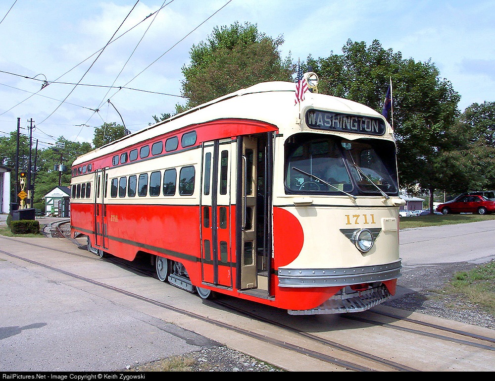
These and other systems have capitalized on the nostalgia aspect of trolleys.  Many lines use either heritage equipment (like San Francisco’s fleet of PCC cars) or new equipment made to look old (like TECO and Little Rock).  It would bring back a lot of memories for Pittsburghers to see trolleys like this


 or this


There is certainly something to be said for marketing your operation correctly and nostalgia is certainly a good way to do it.  However, nothing beats ease of use and good inter-connection.  I like the idea that it spans the entire length of the Strip from downtown all the way to Lawrenceville.  It would be a great way for a Lawrenceville or Strip resident to get downtown or move between the neighborhoods.  

However, the key question which isn’t really addressed here is;  how do you get to the trolley if you’re not one of these residents?  What are it’s connections?  I know there is talk of another trolley circulator to Oakland but that’s a topic for later.  How will someone from the Southside, or the South Hills make use of this trolley without driving to a parking lot in the Strip or Lawrenceville?   The T would make a great connector, but with AVR seemingly going all the way Steel Plaza, that takes away that option. 

Additionally how will someone from Oakland, or Hazelwood, or East Liberty or Garfield get to this line without driving?

 It can be done, after all we’ve got the East Busway for the east end neighborhoods, and supposedly this commuter rail will be an option for people coming from the South, but how this will be integrated and implemented are important discussions that could make or break this operation. 

Lastly, I don't like the idea of putting it on Penn Ave.  I know the plan is to use the circulator to take cars off the streets, in particular Penn Ave. in the Strip.   As a transit guy, I know I’m supposed to believe that putting down rails will take cars off the roads, and I DO believe that.  However, I’m a realist and know a lot of people drive to the Strip on the weekends and that a lot of people will continue to do that as a lot of them are NOT city residents but in fact suburbanites.  I also know that it’s basically bumper to bumper traffic from about 25th St. down through 16th on a Saturday morning.  I think over time that will change but the change will not be immediate.  I think you can get nearly the same effect by putting two tracks in Smallman St. and letting Penn Ave alone.  That said:  it’s not a stake in the heart of the idea. 

The second issue is more of a practical nature.  If you have one track on Smallman and one on Penn, you are creating two at grade crossings of the AVR’s commuter line should it follow its proposed route on 26th St.  Two rail operations crossing at grade are more complex than a road crossing a railroad at grade.  It involves more circuitry, and electronic systems to accomplish.  Why do it twice within a few blocks, making redundant systems when you can do it once, on Smallman St?  You’re not chasing passengers away by having the route one block away with the relatively narrow blocks in the Strip, and you’re saving money on implementation and operating costs. 

Overall, I'm clearly on board with this.  I think it's a great idea and the Strip is a great place to do it.  However, there are some issues that will have to be fleshed out before this aspect of the Riverfront plan could be implemented.  


I was going to cover the additional circulator to Oakland in this post, but seems as though I am rambling and will probably cover that and the “proposed” North Hills to Hazelwood commuter line at the same time. 

Next up:  Water Taxi


*As an aside, that was a major failure with earlier re-development projects in the Pittsburgh area.  The water front is nothing more than a dressed up strip mall with oceans of pavement.  The South Side works, although denser development has few options for transit and no room for transit expansion.  

Monday, February 14, 2011

Lawrenceville Greenway

A full report's finally available on the city's plan for the new "Greenway" which would extend from the DLC to the city line.

Not all of it's transit related, but there are some interesting nuggets, including a trolley "circulator" between Dahntahn and Lawrenceville, some sort of additional circulator between Lawrenceville and Oakland   The oft mentioned commuter rail has popped up once again.  This time including an extension on the old CSX P&W subdivision between Allison Park and Hazelwood (huh?)

I'll have more to say later, but in the mean time; here's the link.

Tuesday, December 28, 2010

Why not a Gondola???

First things first; I learned a valuable lesson early on while researching for this post.

An aerial tram is about as closely related to a gondola as a housecat is to a lion.  While trams and gondolas both travel through the air, are suspended and propelled by cables mounted atop towers, there are some key differences.  (All numbers are approximations and depend on system length, # of vehicles etc.)

Tram               Gondola
Cars/system                                1-2                  10+
Cost/line                                    $15-50 mil       $8-15 mil
Carrier Cap.                              20-50               4-12
System Capacity                        2000/hr            2400+/hr                                             


This idea of an aerial gondola in Pittsburgh popped up a little while ago, and is very intriguing to me.  The idea has been pooh-poohed and at first glance, that notion seems to be accurate.  They’re slow, and can only travel in straight lines without significant upgrades to infrastructure and increases in cost.  Some people may also argue that they are an eyesore high in the sky.

I for one think it’s worth a second glance.  First of all, we’re not trying to connect to the airport here.  This system could be successful as a link within the most dense parts of the city.  Secondly, when compared to the cost for an at-grade or underground rail system, you are looking at an absolute blockbuster bargain (an underground link between downtown and Oakland was estimated at over $1 Billion with a B and an at grade system has been estimated at over $100 million).  An additional positive aspect of an airborne system is the miniscule infrastructure footprint when compared to at grade or underground systems.  Lastly they’re not as slow as you think.  
Detachable technology allows the gondolas to separate from the cable while in a terminal and move independently from the cable which operates at a constant speed.  While the gondolas travel at a literal crawl in each station, they can actually travel as fast as 20 ft/sec once under way.  When you combine that with the fact that they travel in a complete straight line towards their destination, you could be looking at a trip between Oakland and the Southside in a mere 5 minutes.  Five minutes all while taking in beautiful views of our beautiful city.  

Here’s a few interesting reads:


Well, I couldn’t just sit idly by with all this new-fangled and novel transit talk going on and not flex my Google Map muscle.

Essentially, I tried to create a circulator that would take you from nearly any “city core” neighborhood to another relatively easily.  Station placement is key in this scenario because there would be no “intermediate stops” on a given line.  Therefore, easy access to TOD and or other transit is critical for this idea to work.

The system would consist of five color coded lines.  Each line would tie directly into another line at a terminal building and would operate in both directions.  This is to facilitate easy and quick transfer from line to line without a rider having to leave the relative comfort of an enclosed terminal.  Each gondola would ideally hold between 8 and 10 people, and each line would have enough gondolas to keep any transfer time under a minute.   Payment would be rendered at the intial entry station, and an unlimited number free transfers could be made, until a person exits a station and the system. 

Lines:

Blue: Oakland Campus.  This line would connect Fifth Ave. with the Sports Complex.  Would also tie into the Yellow Line at Fifth Ave. and the Red Line at Pitt’s Upper Campus. 

Yellow:  Oakland to Southside.  This line would connect with the Blue Line at Fifth Ave, and the Orange Line in the South Side. 

Orange:  Southside to Mt. Washington.  This line connects with the Yellow Line in the Southside, and the Green Line at Mt. Washington

Green:  Mt. Washington to Uptown.  This line connects with the Orange Line at Mt. Washington, and with the Red Line Uptown. 

Red:  Uptown to Upper Campus.  This line connects with the Green Line at Uptown and with the Blue Line at Pitt’s Upper Campus.   

Stations:

Upper Pitt Campus:  This station serves the Upper Pitt Campus and Hill District.  This station increases the potential for Pitt Students to use the gondola as an alternative to walking up the hill or using a shuttle.  For this service to work however, some sort of free fare system for students would have to be worked out. 
Oakland:  This station would provide access to the heart of Oakland with the Pitt Campus and hospitals.  It would also provide good transit access with the bus routes which traverse 5th Ave and Forbes Ave. 
South Side Flats:  This station would be best situated between the Southside works and Carson St.  This would allow easy access (2-3 blocks in either direction) to the attractions at the Southside Works and Carson St.  This stop would also tie in well with Port Authority service on the South Side. 
Mt. Washington:  This station would offer easy access to the Mon Incline and views of Pittsburgh. 
Uptown:  This station would tie in very well with Current re-development plans for the Civic Arena site and the Consol Energy Center.  The only potential issue with this stop is it does not tie in well with transit downtown. 


View Fun With Aerial Gondolas in a larger map

Again, this is by no means a hard and fast plan, but a mere suggestion at how and aerial gondola could be made a very well patronized, inexpensive, and viable form of intra-city transportation in the City of Pittsburgh.

Thursday, July 23, 2009

Reconciling Sprwal and Transit Part 2

To answer my first two questions from the previous post, I hope so, and yes.

Now to elaborate just a little bit. I personally believe this type of construction or planning will slowly fade away with time. Eventually, it will be seen for what it is, resource consuming, inefficient, and just plain wasteful. Is that time now? I like to think so, but there's not a whole lot of hard facts to say that it is in fact the truth. In the Pittsburgh area specifically, much of the re-development of former industrial sites are in the areas of commercial and residential development. There hasn't been a lot of re-development of former industrial sites in an industrial capacity.

That leads us to the answer of my second question. Because sprawling industrial parks will not suddenly disappear from the landscape, it is worth making an attempt to integrate them with transit, especially those closer to urban centers.

The hard question

Now that I've answered the easy questions, the hard question is how exactly do we integrate these sprawling industrial sites with transit? It's certainly going to cost money, and you will be hard pressed to get the owners of the parks to shell out for the integration. Most likely the authority which operates service to that park would have to shell out, but that's another topic for another post.

Before you can even think of integrating an industrial park, like RIDC East or West, Southpointe, or any industrial park you have to give them decent transit service period. The RIDC Parks have decent bus service, but I'm talking about station stop on a separated grade system, whether that be BRT, LRT or even commuter rail.

In this sprawling environment, simple access is not enough, however. A patron getting off at a central transit stop in a sprawling industrial park could be potentially be faced with a mile+ walk with no sidewalks to their place of employment.

The answer to me is pretty simple; a mini circulator. A small bus that runs on a schedule that is closely tied to the schedule of the connecting transit (BRT, LRT etc.). This circulator should provide at least street corner service, if not front door service (This ability would obviously be impacted on the size of the industrial park). Schedule integration is the key. If someone can get right on a bus from their connecting form of transit, and be able to do so under protection from the elements, they would be much more likely to utilize the transit service as opposed to waiting 5 to 10 minutes for a bus to make a connection, potentially exposed to the elements.

The Harder Question

The biggest sticking point, as usual is the cost. Will this be financially feasible? In my mind a circulator would be a relatively inexpensive investment with relatively low operating costs. The big issue from a cost standpoint is getting the connecting form of transportation (BRT, LRT etc.) to the industrial parks. Most of these parks are missing connections to begin with. That is step 1 to integration, and must occur for these mini circulators to make any sort of sense.

If they (the politicians and public) can be convinced to give industrial parks adequate access to public transit, getting the circulators, by comparison will be easy.

Thursday, July 16, 2009

Reconciling Sprawl and Transit

The United States has seen a resurgence of interest in transit and transportation modes other than private automobiles. While vehicle mileage is still incredibly high, the amount of miles driven has dropped over the last two years after reaching an all time high in 2007. Additionally, more people rode public transit in 2008 than in any of the previous 49 years. Poor economic times, fluctuating gas prices, and continuing negative news about the state of the environment have helped sustain that interest.

Many Americans are beginning to re-think our strategy on transportation and infrastructure. If this trend is to continue it will mean a massive upgrade and expansion of our non-automobile transportation system. While this is clearly positive, in my mind, there is a large amount of sprawling suburban style development which is still in place. Even though this type of development is shrinking, it is doubtful that suburbia is going to disappear anytime soon. This is especially true in the Pittsburgh area. Suburbs such as Cranberry Township (whose population has increased from just under 15,000 in 1990 to approx. 27,000 today) are continuing to expand, despite the economic times and a renewed interest in smart growth.

Sprawling suburban development does not just encompass the cul-de-sac development, there are suburban style strip malls that serve commercial needs and huge sprawling industrial parks with large green lawns, ponds and parking lots larger than the buildings they serve.

These types of developments lend themselves well to automobile transportation but because of the wide distances, large spacing, and long winding access roads they do not lend themselves well to transit integration. A central transit hub or station located in the physical center of any type of suburban development will not usually be sufficient to provide that development, or that mall, or that industrial park with transit service. Spreading the development out makes walking distances longer and even when distances are acceptable, the facilities (i.e. sidewalks) do not often exist to allow people to move between a home/office/store and a central transit hub or station.

I could talk about integrating varying types of suburban development with transit, but for this post I will focus on industrial development. This is partially because of my experience living in the city and commuting to the suburbs and because I think opening up suburban industrial parks to effective transit operations has a good chance for success if done right.

There are many industrial parks in the Pittsburgh area that fit this bill; RIDC Park(s) in Blawnox, and Robinson, Southpointe in Canonsburg, and Westmoreland Business and Research Park, just to name a few.

These existing developments bring up some interesting issues/questions. Are parks like these, "the wave of the past"? Is it worth integrating parks like these? Without "starting over from scratch", how do you integrate these types of parks with expanded transit systems? Is it possible, i.e. financially feasible?

These are all questions I intend to answer (or at least give my opinion on) but this post is growing by the second, so I will leave those opinions for a follow on post.

Monday, July 6, 2009

El Circulatore Spectaculare

Here is the link to my humble submition for the Great Bus-Off of 2009. May the best circulator win!